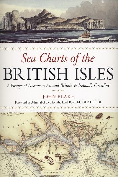
John Blake's paperback version of Sea Charts takes the reader on a circumnavigation of Britain, to explore, through the chart, this multitude of sea ports, fishing and commercial harbours, naval bases and dockyards, and sea-side havens that have supported local life, and defended and imported for the populace at large. Travelling along the coastline clockwise from London and the Thames Estuary the book displays a beautiful collection of charts containing a wealth of information about Britain's maritime history and the story of charting and surveying itself.
They reveal a wealth of information about the developing understanding of these shores, including the dangers of rocks and tides. Furthermore, the bring home the changing nature of the coastline. Some reveal place names now lost to the sea, and ports now stranded miles inland owing to the silting of bays and estuaries.
The great names in British chart-making are all included, such as Captain Greenvile Collins, Professor Murdoch Mackenzie and his nephew of the same name, Graeme Spence and William Bligh. Between them they created the first structured attempts to survey and chart particular areas of the coast of mainland Britain as well as the more remote islands. Examples include several from Collins' 'Great Britain's Coastal Pilot', such as charts of Edinburgh and the Forth, the Orkney Islands, the coast of Ireland and the River Thames; the Chart of the Coast of Wales in St George's Channel and that of Milford Haven by Lewis Morris; The River Clyde and Glasgow by John Watt; and the Observation by Trinity House Pilots and Surveyors of the Downs covering the coast of Kent and the Goodwin Sands, as well as charts by other well-known European chart-makers such as the magnificent example of the Coast of England from Dover to the Isle of Wight showing the Cinque Ports by Lucas Janszoon Wagenaer that dates from 1583.
Maritime archives such as the Admiralty Library, the National Maritime Museum, the Pepys Library, the UK Hydrographic Office and the National Archives have yielded up their unseen nautical records to portray the development of the sea chart in our own coastal waters, and each is explained through extensive captions.